

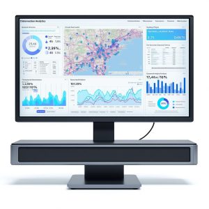
Transform your geospatial data into stunning visual insights with the Advanced Location Data Visualization Suite. This premium software package includes a powerful analytics engine, interactive mapping tools, and customizable reporting features, designed for professionals seeking in-depth location analysis. With an intuitive interface, this suite allows users to visualize trends, patterns, and anomalies in their data seamlessly. The package also includes comprehensive user documentation and access to dedicated customer support for optimal user experience. Perfect for businesses aiming to enhance decision-making through actionable insights.
Customer Reviews
The Advanced Data Visualization Suite offers a robust set of features for location analytics, but it does come with its challenges. The real-time data processing is impressive, allowing rapid insight generation, but the learning curve is steep. Some visualization templates feel outdated and could benefit from modern aesthetics. Additionally, while the software handles extensive datasets well, I experienced occasional lag during complex map overlays. Overall, it’s a solid tool with powerful capabilities, but refinement in user experience would enhance its appeal significantly.
“I can’t believe how much this Advanced Data Visualization Suite has changed my approach to presentations! I was struggling to depict complex location data clearly, but now, with just a few clicks, I can create stunning, interactive maps. My team is more engaged than ever. Total game-changer!”
I recently integrated the Advanced Data Visualization Suite into my workflow, and while it offers solid features for location analytics, it doesn’t quite surpass some competitors like Tableau or Power BI. The ability to create custom geospatial layers is a standout, but the learning curve is steep; I found myself wishing for more user-friendly tutorials. That said, once you get past the initial hurdles, the depth of analysis you can achieve is impressive. Just be prepared for a bit of a time investment.
Product Specifications
| Software Type | Data Visualization and Analytics |
| Compatibility | Windows, macOS, Linux |
| Data Sources Supported | CSV, GeoJSON, Shapefiles, APIs |
| User Interface | Intuitive Drag-and-Drop Interface |
| Map Projections Supported | WGS84, Web Mercator, UTM |
| Features | Real-time Data Updates, Customizable Dashboards, Interactive Filtering |
| License Type | Annual Subscription |
| Customer Support | 24/7 Technical Support |


Reviews
There are no reviews yet.